Perhaps you’re designing communication networks, railway transportation plans, or tracking the commercial performance of your stores with QGIS. Now, your dilemma is ensuring these studies are accessible to other stakeholders in your organization—such as project managers, marketing teams, executives, or clients. You might be wondering: what software can you use to make the most of QGIS?
Below is a list of cloud-based software that allows you to work with maps from QGIS. Some of these tools come with a QGIS extension for seamless synchronization of GIS maps to the cloud, while others require exporting shapes from QGIS.
QGIS Cloud
QGIS Cloud is based on a PostgreSQL database, supporting services like WMS, WFS, and WFS-T. Essentially, QGIS Cloud is a simple solution for publishing your maps online in just a few clicks directly from QGIS.
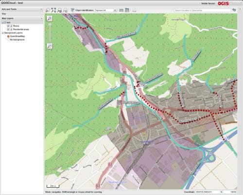
How does QGIS Cloud synchronize with QGIS?
QGIS Cloud has a plugin within QGIS. Simply log into your account to synchronize your map with the cloud.
Who uses QGIS Cloud?
QGIS Cloud is mainly used by individuals. Unfortunately, no companies are known to be using it.
How much does QGIS Cloud cost?
QGIS Cloud offers a free license for non-commercial purposes, allowing you to publish unlimited QGIS maps online. For businesses, there’s a paid version available for €65 (excluding VAT) per month. The premium version includes 10 PostGIS databases and online editing capabilities.
When do I recommend QGIS Cloud?
QGIS Cloud is perfect for students, given the free license for personal use. However, for companies involved in project management, there are more suitable alternatives.
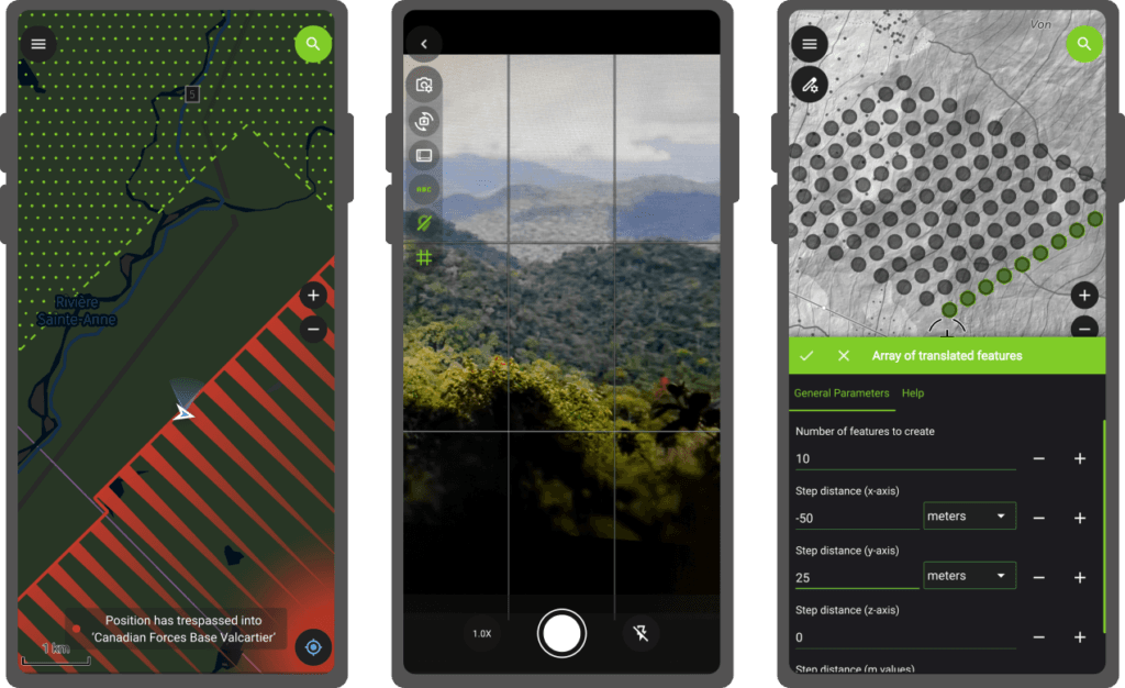
QField
QField is an open-source application initially designed for mobile devices (smartphones and tablets). It preserves the styles of your QGIS project during synchronization and allows editing or deleting objects (points, lines, polygons) directly within the mobile app. It also supports WMS and WMTS feeds.
Who uses QField?
Unlike the first example, QField has gained traction among businesses. Notable users include Deutsche Bahn, the German railway giant, and the United Nations.
How does QField synchronize with QGIS?
QField synchronizes with QGIS through a plugin integrated into the desktop application.
How much does QField cost?
QField is an open-source project, and the application is available for free on both iPhone and Android devices. Windows tablets can also use the QField app.
When do I recommend QField?
QField is particularly popular among NGOs and associations, thanks to its open-source nature, making it an ideal solution for conducting geographical studies. QField is widely used for research on protected areas, such as forests, or in agriculture.
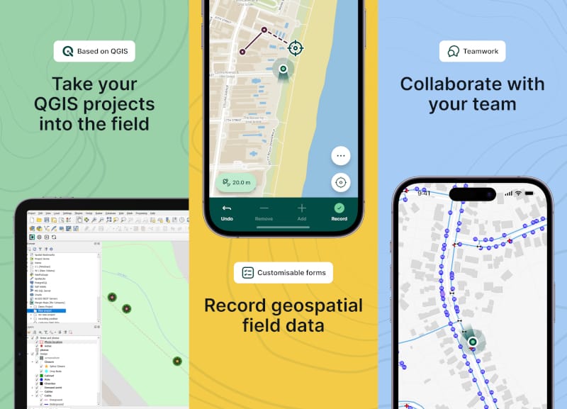
Mergin Maps
MerginMaps is primarily a GIS project mobile application, which recently added a web view. Thanks to its QGIS plugin, it automatically syncs with QGIS, faithfully replicating the filters configured in the software. The app also allows assigning different user permissions and even merging two versions, simplifying project management. Additionally, it can be connected to a GPS (GNSS) pole and its height can be defined, enabling georeferencing directly in the field, with the collected data later processed in QGIS. Photos taken are automatically geolocated.
Mergin Maps supports Geopackage, SHP, WMS, GeoTIFF, and XYZ formats.
Who uses Mergin Maps?
Mergin Maps is used by the Belgian Road Research Center, as well as environmental protection organizations in Africa and Europe. It is also utilized by a forestry cooperative in the Netherlands.
How does MerginMaps sync with QGIS?
Based on my testing, the application works well with SHP formats through the QGIS plugin. However, some formats, such as Boolean, can cause errors. Additionally, Geopackage formats seem to encounter issues, so I recommend using the SHP format instead.
How much does Mergin Maps cost?
As of January 29, 2025, the company significantly increased its prices. Previously, the cost was €149/month (excluding VAT) for 85 users, but now it costs €390/month for 20 users.
When do I recommend Mergin Maps?
Mergin Maps is suitable for companies with project management needs (user management, versioning, etc.). It is particularly targeted at telecommunications companies for network construction projects, as well as agricultural businesses.
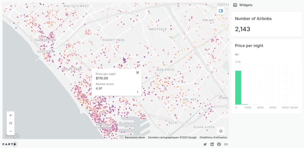
Carto
Carto is a web-based application focused on spatial analysis. It stands out for its ability to connect with a wide range of data, thanks to its API. Another key feature is its ease of sharing maps, for example, on blogs or social media.
Who uses Carto?
Carto is used by a diverse range of companies, including the engineering firm ARUP, the insurance company Swiss Re, the real estate investor JLL, the DIY retailer Leroy Merlin, the dating app Bumble, the telecommunications company Vodafone, the beverage company Coca-Cola, the car manufacturer Renault, and the billboard network Clear Channel.
These are mainly businesses where geolocation plays a significant role in their operations. In fact, this application is designed to rival QGIS in terms of its functionality.
How does Carto sync with QGIS?
Unlike the main alternatives in this article, Carto does not have an application for easy synchronization with QGIS. Instead, synchronization must be done through a database.
How much does Carto cost?
Carto operates in the premium pricing segment, with plans starting at $299/month for a single user.
When do I recommend Carto?
Its seamless sharing experience makes it a preferred solution for bloggers and journalists. Additionally, its extensive data connectivity (e.g., enterprise databases such as Azure or Google Cloud) makes it a strong choice for commercial and marketing professionals who require mapping for economic decision-making.
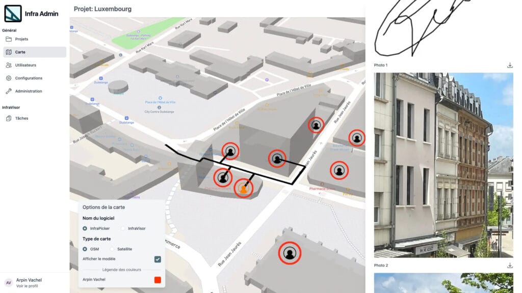
Infracloud
Infracloud is the web counterpart of Spear’s construction management software suite. It enables web-based visualization of information collected in the field using the Infravizor and Infrapicker applications. It also serves as the administrative interface for managing a geographic project. Notably, it allows users to configure different views for various user groups based on the same file.
The application is tailored for construction sites, with features to assign tasks to each object (point, line, polygon) and manage appointments for these objects, which can also be viewed through a Kanban interface. It includes a PDF library to support the map view.
Who uses Infracloud?
Infracloud is used for telecom network construction projects and the installation of electric vehicle charging stations.
How does Infracloud synchronize with QGIS?
There is no native application within QGIS. Shapes must be imported and exported in GeoJSON format. It is also possible to import data in CSV format.
How much does Infracloud cost?
Infracloud offers a free version limited to 2 users, with an enterprise version available starting at €29 per month.
When do I recommend Infracloud?
Infracloud is recommended for projects where study designs are based on QGIS software.
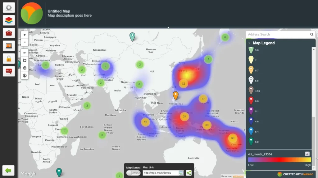
Mangomap
Mangomap is a web application that enables the creation of heatmaps and thematic maps. It is marketed as an affordable alternative to Carto or ArcGIS.
The application supports files in SHP, KML, CSV, GeoJSON, GeoTIFF, and WMS formats.
When do I recommend Mangomap?
Mangomap is ideal for businesses needing online map visualization with a simple interface.
Who uses Mangomap?
Mangomap is used by organizations such as the regional health authorities in Winnipeg.
How does Mangomap synchronize with QGIS?
Mangomap does not directly synchronize with QGIS, but shape files can be imported.
How much does Mangomap cost?
Mangomap starts at $79 per month with an annual subscription.
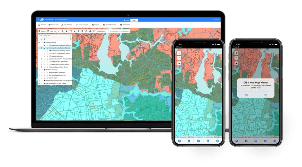
GIScloud
GIScloud is a web and mobile application developed in Europe. It enables sharing and editing of geographic studies and provides a real-time GPS object tracking solution.
Who uses GIScloud?
GIScloud is used by companies like Sotetel, Asterra, and OdcGIS.
How does GIScloud synchronize with QGIS?
GIScloud offers a plugin for QGIS and ArcMap that enables instant synchronization with the cloud.
How much does GIScloud cost?
GIScloud offers three types of licenses based on features. The viewer license costs $12 per user per month, while the editor license is $75 per month with an annual subscription.
When do I recommend GIScloud?
GIScloud is commonly used by public administrations and transportation companies.
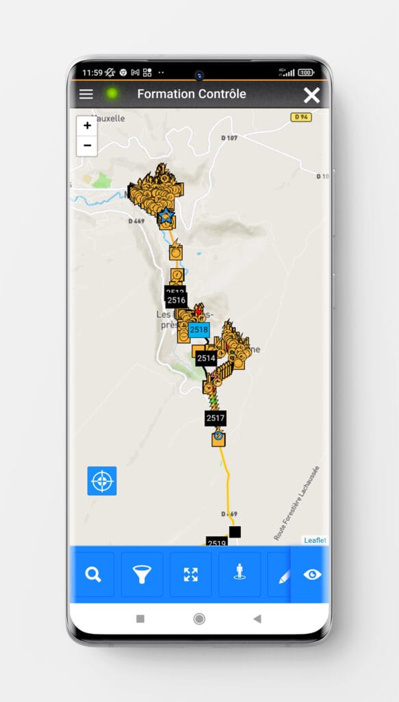
Bluepad
Bluepad is a construction management software based on vector plans, primarily from QGIS. It allows users to take photos of tasks through the mobile application and view them via the web version.
Who uses Bluepad?
Bluepad is used by civil engineering, energy, and environmental companies such as Veolia, Engie, Sanef, and Demathieu Bard.
How does Bluepad synchronize with QGIS?
Shapes need to be imported into the web platform after the company has configured the styles for each shape to be imported. Customization of shapes is charged separately from the subscription.
How much does Bluepad cost?
Bluepad does not publicly disclose its pricing.
When do I recommend Bluepad?
Bluepad is suitable for network construction projects where studies are created in QGIS.